The benefits of taking into account event-related and long-term erosion phenomena in modelling future coastal flooding.
Présentation
Durée : 3 years - before 17 March 2024 !
Summary: Erosion and flooding are phenomena that interact at different timescales. On an event-driven scale, the formation of breaches in dune belts can amplify the intensity of flooding. On a longer time scale (multi-decadal, with effects linked to climate change), the sea level rise will also cause significant changes to the coastline. Coastal flood and coastline retreat (erosion) are among the most significant risks for coastal regions and, although they are linked, their inherent complexity has generally led them to be treated separately, which can lead to highly uncertain estimates. As a result, work on estimates of current and future flooding is most often carried out without taking into account the morphodynamic evolution of the barrier beach, i.e. by neglecting interactions with erosion phenomena. The main aim of this thesis is to develop a modelling method to explore the effects of future long-term changes in the barrier beach on flooding, taking into account both event (storms) and longer-term (e.g. rising sea levels) scales. The sensitivity of flooding to adaptation scenarios (future changes in land use and defence works) will also be explored. The study area will be the Dunkirk coast, which is partly made up of polder areas.
Background and research questions
Current applied studies of coastal flood hazards (e.g. as part of Coastal Risk Prevention Plans, PPRL) use scenarios involving breaches or the collapse of coastal defences, whether natural or man-made (e.g. Dunkirk and Bray-Dunes PPRL1). However, these scenarios are subject to many uncertainties (realism, etc.). On sandy coasts, there is an emerging need for methods and tools that can be used to define realistic scenarios for the evolution of the dune cordon and the creation of potential breaches.
Similarly, in applied or research work on future flooding in the context of climate change (multi-decadal timescales), changes to the coastline (e.g. chronic retreat of the coastline, changes to beach profiles) are most often neglected. In order to limit uncertainties about future flooding, it is therefore necessary to have methods and tools for defining realistic scenarios that include the effect of rising sea levels on coastal development, if possible combined with erosive storm events, not only on extreme water levels at the coast, but also on the topo-bathymetric development of coastal areas potentially subject to flooding.
Finally, most modelling work on future flooding (multi-decadal timescales) neglects the temporal evolution of land use in hydrodynamic models. Only current land use is taken into account. What are the errors induced by this approximation? This highlights the need for a better understanding of the sensitivity of flooding to possible land-use scenarios.
The main research question is as follows: What are the effects of future long-term changes (erosion, adaptation, land use) on the risk of flooding in coastal areas protected by dune belts? The underlying research questions are
- What are the effects of future long-term (erosion) and event-related (i.e. on the temporal scaleof a storm) changes in the barrier beach on flooding (respective effects, joint effects, temporaldominance)?
- How sensitive is flooding to adaptation scenarios (future changes in land use and defenceworks)? How can future land-use change scenarios be estimated on a local scale? What are theeffects of these future changes on flooding? How sensitive is flooding to adaptation scenarios(particularly with regard to defence works)?
- What are the respective and combined effects of changes to the barrier beach and theseadaptation scenarios on flooding in 2050 and 2100?
These questions apply more specifically to the main study site, i.e. the Dunkirk coastline (see Figure 1), over an area stretching approximately from Calais to the Belgian border.
The main objective of the thesis is therefore to model, understand and quantify the effects of morphological changes in the coastline, and in particular the dune belt, in estimating flooding on a regional scale, taking into account different climate change scenarios.
The main scientific advances hoped for are as follows:
- A method for defining realistic scenarios for changes to the coastline over several decades, including the effect of storms (e.g. creation of breaches in the dune belt).
- Estimating the effects of coastal changes caused by rising sea levels and storms on future flooding events.
- Sensitivity of these future projections to adaptation scenarios and changes in land use.
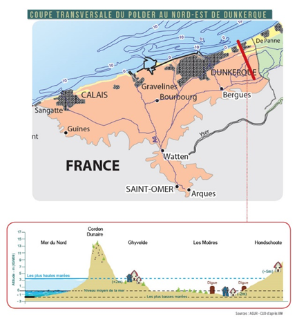
Figure 1 : Study area (~ Territoire des Wateringues downstream of Watten) referred to as the "Dunkirk coastline" in our study and an example of a topographical section. Source: https://www.institution-wateringues.fr.
Brief review of the state of the art and study approaches envisaged
To date, little or no account has been taken of changes in sandy beaches in studies of future flooding. To our knowledge, Toimil et al (2022) are the first to have taken these changes into account, but in a microtidal environment (Mediterranean site). In comparison, the Dunkirk coast is a macrotidal zone, with significant longshore tidal currents (i.e. parallel to the coast) and a more complex coastline (discontinuous dune ridge). Furthermore, although Toimil et al (2022) also considered morphological changes linked to extreme events, they worked on transects (profiles more or less perpendicular to the coastline), and therefore did not fully consider the longshore characteristics (parallel to the coast) of these breaches. This project aims to take this additional dimension into account.
To date, little account has been taken of changes in land use in projections of future flooding based on the use of numerical hydrodynamic models. On the other hand, work has been done to project changes in population and urbanisation (e.g. Merkens et al., 2016, Reimann et al., 2018) or critical infrastructures (Koks et al., 2022). The methods used in this work, combined with local knowledge of the study sites (past trends, development projects, etc.), could be useful for constructing contrasting future scenarios in order to study the sensitivity of flood projections to these land-use change scenarios.
Recent developments in modelling have enabled progress to be made in the modelling of breaches. In the literature, we can find examples of models that have been able to reproduce observed breach events. It should also be noted that breaches can form under different regimes (e.g. wave overtopping only, overtopping then overtopping, overtopping only) and will therefore not have the same behavioural characteristics. Examples include the work by Mc Call et al (2010) on the Santa Rosa barrier island (wave overtopping, then overtopping) and Muller et al (2017) on the Boucholeurs dune barrier (Charentes maritimes, overtopping). These two studies were based on the use of the X-Beach code (Roelvink et al., 2009). The model appears to have good capabilities for capturing/reproducing breaches when an overflow regime is involved. On the other hand, there are fewer examples of simulations that reproduce observed breaches in cases where only wave overtopping occurs. Modelling these real cases requires forcing data (sea level, waves) and initial conditions (topo-bathymetry).
The proposed thesis is of an interdisciplinary nature. It will cover the following disciplines: oceanography, numerical modelling, climate change, geology/geomorphology, coastal hydrodynamics and coastal risks. The subject combines research sector with risk prevention and adaptation sectors (via the study of future flooding in a high-risk area and the involvement of EDF).
This project will be based on the combined use of: methods for projecting future scenarios of sea-level rise2 , hydrodynamic models (water levels and coastal currents, waves, submersion) and morphodynamic models (long-term and event-driven), socio-economic data (for land-use scenarios), topo-bathymetric data and satellite images.
More specifically, with regard to modelling:
- Hydrodynamic forcing: we will use calculation models already implemented by EDF on the study site, in this case based on the openTELEMAC chain.
- Morphodynamics: we will use the ShoreTrans (McCarroll, 2021; profile model) and X-Beach (Roelvink et al., 2009; model jointly resolving hydrodynamics and morphodynamics) models to jointly estimate the effect of rising sea levels on shoreline evolution and extreme events (including the potential formation of breaches). For application to the Dunkirk coastline, it will also be necessary to take into account longshore sediment fluxes induced by tidal/storm currents and waves.
- Hydrodynamics and submersion: we will use the numerical models already installed by EDF on the study site, based on the openTELEMAC chain. It may be necessary to modify or adapt the model configurations already implemented. In addition, the study of the effect of possible changes in land use on flooding will be based on a simplified approach consisting of varying the friction coefficients (representing land use in the model), based on the analysis of existing information and data. In order to take into account scenarios for changes to the defences, we will modify the Digital Terrain Models (DTM) associated with these hydrodynamic models.
With regard to land use scenarios, the approach envisaged is to determine scenarios in a very simplified manner, but based on existing information and data, such as INSEE projections (population, etc.), SSP scenarios3 from the IPCC (but which are not regionalised at the scale of the study site). The work carried out as part of the HE CoClico project4 (BRGM coordinator) may also be analysed. The definition of these scenarios will also be based on an analysis of local adaptation strategy documents and available hazard studies.
Lastly, data on changes in relative mean sea level over time (past and future) will be produced and made available by BRGM.
The LHSV, EDF and BRGM will make their computing resources available. In addition to the public data that will be used, the data will mainly come from existing datasets or those planned for acquisition in future projects. Coastline data may also be extracted from the analysis of satellite images available free of charge on the Google Engine.
References
- McCarroll et al. (2021) A novel rules-based shoreface translation model for predicting future coastal change: ShoreTrans, https://doi.org/10.1016/j.margeo.2021.106466.
- Merkens et al. (2016) Gridded population projections for the coastal zone under the Shared Socioeconomic Pathways. Global and Planetary Change, 145, 57-66.
- Koks et al. (2022) The impacts of coastal flooding and sea level rise on critical infrastructure: a novel storyline approach, Sustainable and Resilient Infrastructure, DOI: 10.1080/23789689.2022.2142741
- McCall et al. (2010) Two-dimensional time dependent hurricane overwash and erosion modeling at Santa Rosa Island, Coastal Engineering, https://doi.org/10.1016/j.coastaleng.2010.02.006.
- Muller et al. (2017) Assessing storm impact on a French coastal dune system using morphodynamic modeling. https://doi.org/10.2112/JCOASTRES-D-15-00102.
- Reimann et al. (2018) Regionalized Shared Socioeconomic Pathways: narratives and spatial population projections for the Mediterranean coastal zone. Regional Environmental Change, 18(1), pp.235-245.
- Roelvink et al. (2009) Modelling storm impacts on beaches, dunes, and barrier islands. https://doi.org/10.1016/j.coastaleng.2009.08.006.
- Toimil et al. (2022) Neglecting the effect of long- and short-term erosion can lead to spurious coastal flood risk projections and maladaptation, Coastal Engineering, https://doi.org/10.1016/j.coastaleng.2022.104248.
Partnership and thesis supervision
The thesis will be carried out in collaboration between the LHSV, BRGM and EDF. This will be a CIFRE thesis, with EDF as the industrial partner in the application submitted to the ANRT and as the doctoral student's employer (36-month fixed-term contract). The doctoral student will be housed at the LHSV, a joint research unit of EDF R&D and the Ecole des Ponts ParisTech, and enrolled in the Sciences, Engineering, Environment (SIE) ED 351 doctoral school at Paris-Est Sup.
The thesis will be supervised by M. Benoit (EDF and LHSV), thesis director, D. Idier (BRGM), thesis co-director, with co-supervision of M. Teles (EDF), V. Bacchi (EDF), N. Valentini (BRGM), and R. Thiéblemont (BRGM).
The PhD student will be based mainly at the LHSV in Chatou (78), with stays at BRGM-Orléans, BRGM-Montpellier and Dunkerque.
Additional collaboration will be established with the LOG laboratory (Laboratoire d'Océanologie et de Géosciences, UMR 8187 - CNRS | ULille | ULCO | IRD), which will bring its knowledge of the Dunkirk coastline and the phenomena at play. During the set-up phase and at the start of the project, the focal point will be Marie-Hélène Ruz.
Provisional work programme
Task 1 [year 1]: Getting familiar with the subject, the state of the art and the study site. This phase will enable the PhD student to familiarise himself with the phenomenological knowledge, the state of the art, the knowledge of the study site, the proposed methodology, to refine it, to better identify the potential contributions of his work to the state of knowledge, and finally to specify the research sub-questions and the work programme of his thesis. Among other things, the PhD student will review the state of knowledge of the Dunkirk coastline in terms of data, existing studies and the phenomena at play in submersion events on the study site (including the drainage channels associated with the wateringues), and the issues at stake. He/she will summarise the past evolution of the coastline and dune cordon, as well as flooding events and potential breaches. He/she will also analyse the topographical and bathymetric data available, together with an analysis of water levels. All these elements will enable an initial identification of the most fragile dune/sand areas (/ flooding). The PhD student will also use the hydrodynamic models already in place and existing forcing data. Less specifically to the study site, he/she will review the various types of modelling of the evolution of the coastline and the morphology of the barrier beach, both on event and longer-term scales (e.g. X-Beach, ShoreTrans, IH-LANS, LX-Shore, etc.). He/she will also acquire basic knowledge of climate projections and shared socio-economic pathways (SSP).
Task 2 [year 1]: definition of an idealised test case representative of the study site, methodological development and application. At least the following phenomena will be taken into account: (1) longshore sediment flows (via modelling or data analysis), (2) the effect of rising sea levels (via the use of the ShoreTrans code), (3) longshore and cross-shore sediment transport during extreme events (via the use of the X-Beach code). This test case will go as far as estimating submergence and will aim, among other things, to: (1) implement the strategy and tools needed to couple these different components (e.g. reconstruction of 2D topo-bathymetry before calculating submersion), (2) explore the potential 1ère effect of changes in the barrier beach (and breaches) on submersion.
Task 3 [year 2 & 3]: application to the Dunkirk coastline. The main stages will be:
- Implementation of the method and codes on the Dunkirk coastline. A 2D version of X-Beach will be implemented in areas identified as potentially subject to brecciation phenomena. This implementation will include a validation stage for the models implemented (comparison with observations).
- Definition of hydrodynamic scenarios and study of the effect of changes to the barrier beach: in a 1st approach, future tidal conditions, waves and surges will be considered to be the same as for the current period. The effect of climate change will mainly be reflected by taking into account the rise in sea level. An initial set of simulations of changes in the barrier beach and submergence will be carried out to identify the zones of the barrier beach that have a significant influence on flood, and also to estimate the respective contributions of long-term and event-related changes to water levels at the coast and flood. Particular attention will be paid to taking proper account of the wateringues and the discharge of water through this network.
- Defining adaptation scenarios (defence works) and land use and studying the sensitivity of floodingto these scenarios: to complete the study, variants of the current situation will be considered,simulations carried out and the respective and joint effects analysed.
Task 4 [year 1, 2 et 3]: communication and exploitation of results (A-rank publications, national and international conferences, knowledge transfer). He or she will also take part in the Ecole des Ponts ParisTech and BRGM doctoral student days, as well as team seminars.
[1] https://www.nord.gouv.fr/Politiques-publiques/Prevention-des-risques-naturels-technologiques-et-miniers/Plans-de-Prevention-des-Risques-Littoraux-PPRL/Le-PPRL-de-Dunkerque-et-Bray-Dunes
[2] Projections of future sea level rise scenarios will be carried out by BRGM as part of a complementary action.
[3] SSP: Shared Socio-economic Pathways.
[4] https://coclicoservices.eu/
Profile and skills expected of candidates
The candidate must:
- hold a Master 2 or an engineering degree (Earth Sciences/Oceanography or Fluid Mechanicsand/or Numerical Calculation);
- master at least one programming language for data processing and analysis (e.g. Python,Matlab);
- have a good level of English (read, written and spoken).
If possible, the candidate should have:
- knowledge of coastal geomorphology and morphodynamics;
- skills in hydrodynamic and/or morphodynamic modelling and geographic information systems;
- notions of Fortran and Geographic Information Systems (GIS) ;
- the following qualities: autonomy, scientific curiosity, open-mindedness, ability to listen andwork as part of a team, writing and oral presentation skills.
Application procedure
Applicants must have the required degree (master's or equivalent) at the time of the start date of their contract. The doctoral contract is for a period of 3 years (fixed-term contract with the EDF as employer), with a target start date between July 1 and October 1, 2024 (depending on the wishes of the doctoral student and the time taken by the ANRT to process the application).
Target start date of thesis: Between 1er July and 1er October 2024
Encadrement
Laboratoire de recherche d’accueil
Saint-Venant Hydraulics Laboratory (LHSV) (Ecole des Ponts, EDF), 6 quai Watier, 78400 Chatou, France
https://www.saint-venant-lab.fr
Financement et employeur
CIFRE thesis with employer EDF R&D (3-year fixed-term contract), subject to ANRT (Agence Nationale Recherche Technologie) approval
Ecole doctorale
Sciences, Engineering, Environment (SIE) ED 351 of Paris-Est Sup
https://www.paris-est-sup.fr/ecoles-doctorales/ecole-doctorale-sciences-ingenierie-et-environnement-sie/
Direction de thèse
Dr. Michel Benoit, EDF R&D LNHE and LHSV, senior researcher, HDR
https://scholar.google.com/citations?user=EiMB7SgAAAAJ&hl=fr
Dr. Déborah Idier, BRGM, Senior Researcher-Engineer, HDR
https://www.researchgate.net/profile/Deborah-Idier
Co-encadrants de thèse
Dr. Vito Bacchi, Researcher-Engineer EDF R&D LNHE
Dr. Maria Teles, Researcher-Engineer EDF R&D LNHE
Dr. Rémi Thiéblemont, Senior Researcher-Engineer, BRGM
Dr. Nico Valentini, Senior Researcher-Engineer, PhD
Contacts
Applicants should send the following documents by email to Michel Benoit (michel.benoit@edf.fr) and Déborah Idier (d.idier@brgm.fr) before 17 March 2024: covering letter, CV, Master's transcript and the contact details of two referees.
Ce poste vous intéresse ?
Postulez en remplissant le formulaire ci-dessous.
Important : pour faciliter leur traitement, nous n'acceptons que les candidatures électroniques.
Pour candidater, merci de remplir le formulaire ci-dessous.
Toutes les informations fournies par vous resteront confidentielles et ne seront ni divulguées ni mises à disposition d’un autre organisme sans accord préalable écrit de votre part. Selon la loi informatique et libertés, vous disposez d’un droit d’accès et de rectification aux données vous concernant.
